Pokhara's Demolition of Illegal Structures Around Phewa Lake
Pokhara, a city known for its scenic beauty and tourist attractions, experienced a dramatic shift as excavators roared through the early morning hours on Saturday. The city, still damp from Friday night’s rain, witnessed the start of a major operation targeting illegal structures built within the boundaries of Phewa Lake.
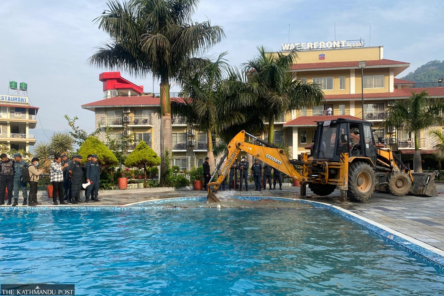
Tourists at the Waterfront Resort on the lakeside observed the changes as the once-clear blue water of the swimming pool turned muddy yellow. This was the result of an excavator digging into the area, marking the beginning of a significant effort to enforce a Supreme Court order.
The Pokhara Metropolitan City initiated the demolition in coordination with the home ministry, following instructions from Prime Minister Balendra Shah. The operation involved 32 illegal structures that had been erected within the lake's boundary. Around 150 personnel from various police forces were deployed to ensure the process went smoothly.
Dhanraj Acharya, the Pokhara mayor, emphasized that the demolition was not done without prior notice. He explained that multiple notices had been issued before the operation began, and it was conducted early Saturday as per the Ministry of Home Affairs’ instructions.
The action came after a Supreme Court verdict on 20 June 2023, which mandated that the 65-meter zone around Phewa Lake must be maintained as a "green zone." The court ordered the removal of all unauthorized structures, including hotels, resorts, and businesses, within six months.
Crucially, the court ruled that land registered after the 1976 survey was fraudulent. This interpretation of the Land Revenue Act 1977 meant that any public or government land registration in the name of individuals is automatically void. Therefore, no compensation needs to be paid for land registered after 1976.
Compensation is only required for those who held valid titles before the 1976 survey and have consistently paid land taxes since. The verdict also instructed the government to cancel land registration of encroached areas within the 65-meter zone and provide compensation for lands registered before 2032 BS (1976), restoring them as lake property.
To implement this, a facilitation committee was formed under Gandaki Province Chief Minister Surendra Raj Pandey. A technical sub-committee led by Chief Survey Officer Gangalal Pokhrel was tasked with identifying the lake's highest water level and demarcating the 65-meter boundary. Using DGPS technology and drone surveys, the subcommittee recently determined the lake's area to be 6.343 square kilometers—significantly larger than previously recorded figures.
Earlier, on February 20, the city office issued a public notice asking owners to remove illegal structures around the lake within 15 days, warning that they would be removed at the owners' expense if they failed to comply. Despite repeated notices, most structures remained intact.
After the government included the Phewa Lake conservation in its reform agenda, Prime Minister Balendra Shah personally called Acharya on March 29 to get an update on the execution of the court order. A week later, the demolition began, as directed by the home ministry, under tight security amid protests and strong objections from local residents.
Nabin Baral, chairperson of Phewa Lake Victims' Concern Committee, criticized the operation, calling it an act of state-sponsored terror. He argued that demolishing properties without any compensation was condemnable.
Acharya, however, defended the action, stating that several permanent structures were deliberately built within the 65-meter zone. He emphasized that such structures were erected without giving notice to the metropolis and would not receive any compensation. For land with legal registration, the compensation process would soon begin.
The current state of Phewa Lake is largely a result of geographical shifts seen after 1961. In that year, the Nepal-India Cooperation Mission constructed a dam on the eastern side of the lake, and the government introduced its first land acquisition and compensation policies. Historical records suggest the lake spanned 4 square miles (10.36 square kilometers) at that time, though contemporary researchers have struggled to find empirical data to verify this area.
The legal framework for protection began in 1973. Following the approval of the Pokhara Town Plan, a government gazette notification on November 30, 1973 designated Phewa as a protected area. It strictly prohibited any form of construction within 200 feet (60.69 meters) of the lake's perimeter.
However, a catastrophic failure of the Phewa dam in 1974 changed everything. As the dam collapsed, the water level receded dramatically, exposing vast tracts of the lakebed at the northern end. This exposed land quickly turned into marshland, which local residents began to cultivate. In 1976, a central survey team arrived in the area. Taking advantage of the exposed land, many local residents managed to register plots as private property during the 1976-1977 land survey.
By the time a new dam was completed in 1981 and the water levels rose again, these "private" plots were once more submerged. A 1981 study by the Nepal government and the United Nations Development Project subsequently recorded the lake's area at a diminished 5.8 square kilometers.
The 65-meter buffer zone rule, which is currently the subject of intense debate, traces its roots to a 2007 decision by the Kaski District Council. Building on the 1973 town plan, the council moved to prohibit any physical structures within 65 meters of the shoreline.
When this decision was ignored and encroachments intensified, advocates Khagendra Subedi and Ramesh Ghimire filed a writ petition in the Supreme Court on 24 January 2011, naming the Office of the Prime Minister and 15 other government agencies as defendants.
In response, then-prime minister Baburam Bhattarai formed a high-level committee led by Bishwa Prakash Lamichhane, chief of the Pokhara Valley Town Development Committee, to investigate the encroachment. The 2012 Lamichhane report was a bombshell: it revealed that 1,692 ropanis (2498.29 hectares) of lake land had been illegally registered in the names of individuals.
The report detailed how, during the 1976 survey, locals influenced officials to plot areas ranging from 150 to 750 meters in length across what should have been the lake's surface. Approximately 500 ropanis of this land, held by 950 individuals, currently remain underwater. Lamichhane's recommendation was clear: the land titles for these 1,692 ropanis must be revoked.
On April 29, 2018, Supreme Court Justices Om Prakash Mishra and Sapana Pradhan Malla issued a landmark order based on this report. They directed the government to fix the lake's boundaries within six months, remove structures within the 65-meter zone, and acquire necessary land by paying compensation.
Yet, as years passed without action, contempt of court cases were filed. In 2020, the KP Sharma Oli government formed another committee led by Punya Paudel, which eventually recommended a lake area of 5.726 square kilometers—a figure that got official recognition later.
The conflict escalated when in 2021, then-Mayor Man Bahadur GC tried to reduce the buffer zone from 65 meters to 30 meters. This decision met with immediate legal challenges. On June 20, 2023, the Supreme Court delivered its final blow to the encroachers.
Crucially, the court ruled that land registered after the 1976 survey was fraudulent. The verdict interpreted the Land Revenue Act 1977 to mean that any private ownership of public or government land is automatically void. Therefore, no compensation needs to be paid for land registered after 1976.